This analysis was produced with the help of artificial intelligence, based on the weather data provided by the user.
August 2026 closed the summer on a subdued note. It was a month without a single genuinely hot day, with a rainfall total well under half of the long-term average, and with the weakest peak wind gusts the station has recorded in an August for years. The observations below are drawn from continuous 30-minute measurements at the station, and the comparisons use the full August record from 2003 to 2025 — 23 previous Augusts.
Weather Analysis
The mean temperature for August 2026 was 16.3 °C, which is 0.9 degrees below the long-term August average of 17.2 °C. That makes it the seventh coolest August in the 24-year record, following a run of below-average Augusts — 2025 (15.9 °C), 2021 (15.9 °C) and 2016 (16.1 °C) were all cooler still. Averaged over the month, daytime highs reached 19.7 °C and nights dropped to 13.3 °C, giving a modest daily swing of just over six degrees, typical of a month dominated by cloud and moist air rather than clear skies.
The most striking feature of the month is the maximum temperature of 23.3 °C, measured on 15 August at 15:30. In a normal August the station records a peak of about 27 °C, and in the warmest years the reading has climbed above 30 °C — 33.1 °C in 2014, 32.5 °C in 2023. August 2026’s peak is the second lowest August maximum in the entire record, marginally above the 23.2 °C of 2021. Not one day in the month reached 25 °C, although 16 of the 31 days did climb to 20 °C or above, so the month was persistently mild rather than genuinely cold.
The other end of the scale tells the same story from the opposite direction. The minimum temperature was 10.6 °C, recorded on 19 August at 02:00. That is well above the long-term August minimum average of 9.5 °C, and among the mildest August minima on record. There was no cold snap: the temperature never approached the single figures that most Augusts produce at least once. In other words, the month was compressed at both ends — no heat, but no chill either — and the whole distribution simply sat about one degree below normal.
Within the month, the first ten days were the warmest stretch (mean 17.3 °C), peaking on 6 August with a daily mean of 19.2 °C. A distinctly cooler middle period followed from 11 to 20 August (mean 15.5 °C), which also contained the coldest day of the month, 20 August, at 14.2 °C. The final third recovered only slightly, to 16.2 °C.
Humidity averaged 84.0 %, above the long-term August mean of 81.9 % and among the more humid Augusts on record. Individual readings ranged from 51.9 % to 98.0 %, and on four days the daily average exceeded 94 %, with the air close to saturation around the clock. This persistently damp air is consistent with the muted temperature range: moisture and cloud suppressed both daytime heating and night-time cooling.
Mean air pressure was 1011.1 hPa, almost exactly the long-term August average of 1010.6 hPa, but the month was far from uniform. Pressure fell to a monthly low of 997.5 hPa on 20 August, when a low-pressure system delivered the heaviest rain of the month, and rose to 1027.0 hPa on 27 August during a settled, high-pressure spell in the final week. That 29.5 hPa spread between the extremes captures the month’s structure well: an unsettled middle section bracketed by two quieter, higher-pressure periods.
Wind averaged 2.8 m/s, somewhat above the long-term average of 2.4 m/s, so the month was breezy in an everyday sense. The maximum gust was only 13.9 m/s, from the southwest on 9 August at 18:00 — the fifth lowest August peak gust in the record, against a long-term average peak of 16.1 m/s and against 21.5 m/s in 2023. The month therefore combined a steady, moderate airflow with a complete absence of storm-force gusts. The prevailing directions were southwesterly and southerly, which brought in the mild, moist maritime air that characterised the month.
Rainfall Analysis
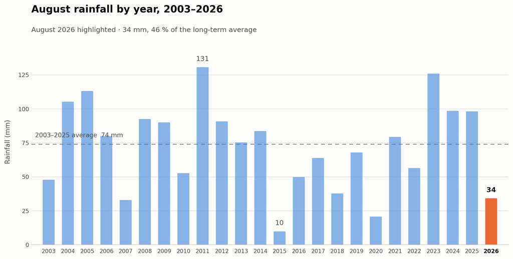
Total rainfall for August 2026 was 34.2 mm, against a long-term August average of 74.1 mm. The month therefore delivered only 46 % of normal August rainfall, a deficit of about 40 mm, and ranks as the fourth driest August in the 24-year record. Only 2015 (9.9 mm), 2020 (20.8 mm) and 2007 (33.0 mm) were drier. For comparison, the wettest August on record, 2011, produced 130.7 mm — nearly four times this year’s total — and the average of the last ten Augusts alone is 69.9 mm.
Rain fell on 12 days at 0.2 mm or more, but only 8 days produced at least 1 mm, and no day exceeded 7.2 mm. The month was thus dry not because rain events were rare, but because they were consistently light: the station never recorded the heavy day-long rainfall that normally lifts an August total past 70 mm.
The distribution across the month was strongly uneven. The first nine days were completely dry, the longest rainless spell of the month, and the whole first half yielded just 7.6 mm. The remaining 26.6 mm fell in the second half, concentrated around two unsettled periods: 20–23 August, which brought 17.2 mm including the wettest day of the month (7.2 mm on 20 August), and the closing days 29–31 August, which added 9.0 mm. The heaviest short-duration rainfall occurred on 20 August at 12:30, when the rain rate briefly reached 35.6 mm/h, though the shower was too short to accumulate much. A second dry spell of five days ran from 24 to 28 August under the high-pressure ridge.
Seen in the context of the whole summer, August’s dryness is a reversal rather than a continuation. June 2026 was exceptionally wet at 92.6 mm against an average of 37.6 mm, and July 2026 also ran wet at 77.6 mm against 52.7 mm. The summer as a whole was therefore wetter than normal, with August alone providing the dry interlude.
Rainfall Comparison Chart
The chart below shows total August rainfall for every year from 2003 to 2026, with August 2026 highlighted. The dashed line marks the 2003–2025 average of 74 mm. The chart makes clear how far below the long-term norm this August fell, and how much year-to-year variability the station’s August record contains — from under 10 mm in 2015 to over 130 mm in 2011.
Overall Assessment
August 2026 was a cool, dry and unusually calm month, with no weather extremes in any direction. Its defining characteristic was the absence of heat: with a maximum of 23.3 °C, it was the second coolest August peak in 24 years, and the mean temperature of 16.3 °C continued the recent run of below-average Augusts. At the same time, the mild minimum of 10.6 °C, the high average humidity of 84.0 % and the small daily temperature range point to a month spent under moist southwesterly air and persistent cloud, which kept both heat and frost-adjacent cold at bay.
Rainfall, at 34.2 mm or 46 % of normal, was the month’s other notable anomaly, though it should be read alongside a wet June and July rather than as a summer-long drought. Only the second half of August produced meaningful rain, and even then in light, short-lived events.
Taken together, the month can fairly be described as quiet weather: no heat waves, no cold snaps, no storms — the peak gust of 13.9 m/s was among the lowest ever recorded here in August — and no heavy rainfall days. For the record books, August 2026 will be remembered less for what happened than for what did not: it is the summer month in which the station’s thermometer never reached 25 °C.
Key figures at a glance
| Measure | August 2026 | 2003–2025 average |
|---|---|---|
| Mean temperature | 16.3 °C | 17.2 °C |
| Maximum temperature | 23.3 °C (15 Aug) | 27.3 °C |
| Minimum temperature | 10.6 °C (19 Aug) | 9.5 °C |
| Mean humidity | 84.0 % | 81.9 % |
| Mean air pressure | 1011.1 hPa | 1010.6 hPa |
| Pressure range | 997.5 – 1027.0 hPa | — |
| Mean wind speed | 2.8 m/s | 2.4 m/s |
| Maximum gust | 13.9 m/s (9 Aug, SW) | 16.1 m/s |
| Total rainfall | 34.2 mm | 74.1 mm |
| Rain days (≥ 0.2 mm) | 12 | — |
