This analysis was produced with the help of artificial intelligence, based on the weather data provided by the user.
Weather Analysis
June 2026 was a month of two distinct halves. The first half was cool and unsettled, with a mean temperature of just 14.5 °C, while the second half turned progressively warmer, averaging 17.2 °C. Overall, the monthly mean temperature settled at 15.8 °C, slightly above the long-term June average of 15.2 °C recorded at this station since 2004.
The month began on a chilly note: the lowest temperature of the month, 9.0 °C, was measured in the early hours of 1 June at 05:00. Cool conditions persisted through mid-month, with 14 June standing out as the coldest day, averaging only 12.2 °C under low pressure and heavy rain. Summer warmth arrived in earnest during the final week. The warmest day was 27 June with a daily mean of 20.2 °C, and the month’s highest reading of 26.7 °C was recorded on 29 June at 15:00. Two days — 27 and 29 June — saw maxima at or above 25 °C, meeting the Finnish threshold for a hot day (helle).
Average relative humidity was high at 80 %, reflecting the wet character of the month, with readings ranging from 38 % during the warm, dry spell late in the month to 98 % during rain events.
Air pressure averaged 1012.5 hPa. The barometric low point of 995.6 hPa occurred on the morning of 14 June as an active low-pressure system crossed the region, bringing the month’s coldest and one of its wettest days. Pressure peaked at 1022.7 hPa on 23 June as high pressure built in ahead of the warm final week.
Winds were moderate throughout the month, averaging 2.5 m/s with a clear prevailing direction from south-southwest and south. The strongest gust of the month, 13.4 m/s, was recorded on 10 June at 16:30.
Rainfall Analysis
Rainfall was the defining feature of June 2026. The month delivered a total of 92.6 mm, which is 241 % of the historical June average of 38.5 mm (2004–2025) and makes it the wettest June in the station’s record, comfortably surpassing the previous high of 78.8 mm from June 2012.
Rain fell on 11 days (≥ 0.2 mm), but the bulk of the monthly total came from three major events. The wettest day was 15 June with 30.6 mm — nearly a third of the monthly total in a single day — followed by 20.2 mm on 6 June and 18.4 mm on 14 June. The 6 June event was particularly intense, producing the month’s peak rainfall rate of 65.8 mm/h at 13:30, indicative of heavy convective showers. Together, the period 14–15 June brought 49.0 mm, more than an entire average June’s worth of rain in 48 hours. In contrast, the final ten days of the month were largely dry, coinciding with the building high pressure and rising temperatures.
The contrast with recent years is striking: June rainfall totals of 3.4 mm (2021), 12.9 mm (2022), and 11.4 mm (2023) marked a run of exceptionally dry early summers, whereas 2024 (66.8 mm), 2025 (57.0 mm), and now 2026 (92.6 mm) represent three consecutive Junes well above the long-term average.
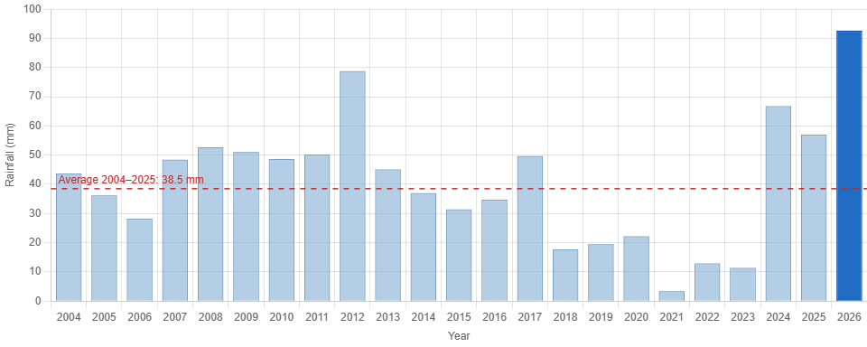
Key figures from the chart: 2026 — 92.6 mm (record); previous record 2012 — 78.8 mm; historical average — 38.5 mm; driest June — 2021 with 3.4 mm.
Overall Assessment
June 2026 will be remembered above all for its record-breaking rainfall — 92.6 mm, nearly two and a half times the long-term average and the highest June total in more than two decades of station records. Thermally the month was close to normal (15.8 °C against a 15.2 °C average), but this headline figure conceals a cool, wet, and unsettled first three weeks followed by a warm and dry finish, capped by the month’s high of 26.7 °C on 29 June. The heavy mid-month rainfall, delivered largely in a few intense events, replenished soil moisture thoroughly after what had been a fairly typical spring, and set the stage for July with abundant ground water and, in the final days of June, genuinely summery warmth.
