This analysis was produced with the help of artificial intelligence, based on the weather data provided by the user.
September 2026 brought a gentle, damp start to autumn. The month was slightly warmer than average, but the warmth came from mild nights rather than warm days, and it was wetter, more humid and lower in pressure than a typical September. Like August, it passed without any real extremes: no late-summer heat, no early frost and no storm-force winds. The observations below are drawn from continuous 30-minute measurements at the station, and the comparisons use the full September record from 2003 to 2025 — 23 previous Septembers.
Weather Analysis
The mean temperature for September 2026 was 13.5 °C, which is 0.4 degrees above the long-term September average of 13.1 °C. That makes it the ninth warmest September in the 24-year record — comfortably on the mild side, but some way short of the warmest years, 2023 (15.2 °C), 2006 (14.7 °C) and 2020 and 2024 (both 14.6 °C). Averaged over the month, daytime highs reached 16.5 °C and nights fell to 10.8 °C. The daily swing of under six degrees was narrow even by autumn standards, reflecting a month spent mostly under cloud.
The maximum temperature was 20.6 °C, measured on 1 September at 16:00. That is below the long-term September average peak of 21.3 °C, and it was the only time the month reached 20 °C. It was effectively summer’s last word: after the first week the warmth faded quickly, and from 8 September onwards no day climbed above 16.7 °C. For comparison, the warmest September reading on record is 26.5 °C, from 2024.
The minimum temperature was 7.2 °C, recorded on 23 September at 08:30. This is the month’s most remarkable figure. The long-term average September minimum is 5.1 °C, and in the coldest years the station has dropped to 1.5 °C (2014) and 2.0 °C (2013). September 2026’s minimum is the second mildest in the record, beaten only by 2020 (8.7 °C). Nights dropped below 10 °C on ten occasions, but never came close to frost. The month’s above-average mean temperature is therefore a story about the absence of cold nights, not about warm days.
Within the month, temperatures followed a steady seasonal decline. The first ten days were the warmest (mean 14.6 °C), with 1 September the warmest day at a daily mean of 17.0 °C. The middle period from 11 to 20 September averaged 13.7 °C, and the final third cooled to 12.3 °C. The coldest day was 23 September (10.8 °C), which followed a clear, high-pressure night.
Humidity averaged 88.6 %, above the long-term September mean of 86.1 % and the sixth most humid September on record. Individual readings ranged from 56.5 % to 98.0 %. On five days the daily average reached 95 % or more — 8, 9, 16, 25 and 26 September — all of them rain days, when the air stayed close to saturation around the clock. This persistent moisture went hand in hand with the mild nights and the small daily temperature range.
Mean air pressure was 1010.4 hPa, 2.2 hPa below the long-term September average of 1012.6 hPa and the fifth lowest September mean on record. The month also had an unusually wide spread. Pressure fell to a low of 994.1 hPa on 5 September at 03:30 as a deep low passed, and stayed generally low through an unsettled middle section, with daily means around 998–1004 hPa between 16 and 20 September. The final days then brought a sharp turnaround: a strong high-pressure system built from 27 September, and pressure peaked at 1037.5 hPa late on 30 September. The 43.4 hPa range between the extremes reflects a month that moved from low-pressure dominance to a firmly anticyclonic close.
Wind averaged 2.6 m/s, almost exactly the long-term September average of 2.7 m/s. The maximum gust was 16.1 m/s, from the southwest on 20 September at 02:30, during the last of the mid-month low-pressure systems. That is well below the long-term average September peak gust of 18.8 m/s, and it is the fifth lowest September peak gust in the record — a long way from 29.5 m/s in 2020 or 27.4 m/s in 2019. The windiest stretch of the month ran from 16 to 20 September. The prevailing directions were south-southwesterly, southwesterly and southerly, bringing in the mild, moist air that defined the month, with a shorter northerly and northwesterly component behind the passing fronts.
Rainfall Analysis
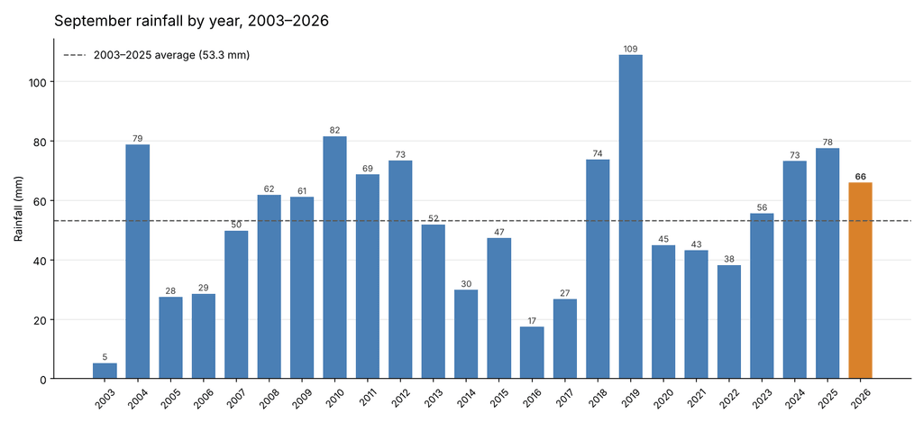
Total rainfall for September 2026 was 66.0 mm, against a long-term September average of 53.3 mm. The month therefore delivered 124 % of normal September rainfall, a surplus of about 13 mm, and ranks as the ninth wettest September in the 24-year record. The wettest September by a clear margin remains 2019 (109.0 mm), followed by 2010 (81.6 mm) and 2004 (78.8 mm); at the other end, September 2003 produced only 5.3 mm. The average of the last ten Septembers is 56.0 mm, so this year continues a recent run of wetter-than-average Septembers: 2023, 2024 and 2025 were also above the norm.
Rain fell on 15 days at 0.2 mm or more, and on 9 days at 1 mm or more. Seven days produced at least 5 mm and two exceeded 10 mm: 10 September with 16.8 mm, the wettest day of the month, and 25 September with 10.0 mm. In contrast to August, when rain arrived only in light showers, September rain came in several substantial frontal episodes.
The month opened with six completely dry days (1–6 September), the longest dry spell of the month. The first and wettest rainy period followed between 7 and 10 September, which together produced 30.0 mm — almost half of the month’s total. Its peak came on 10 September at 12:30, when an intense downpour delivered 14.2 mm in half an hour, with a peak rain rate of 93.6 mm/h. That single half-hour accounts for more than a fifth of the whole month’s rain. A second unsettled period from 16 to 20 September added 17.6 mm, and a third on 25–26 September brought 16.2 mm. The final four days, under the building high, were practically dry. Split into thirds, the month’s rain fell as 30.0 mm, 18.0 mm and 18.0 mm.
Seen in the context of the season, September resumes the wet pattern of early summer after August’s dry interlude. June 2026 had 92.6 mm (average 37.6 mm), July 77.6 mm (average 52.7 mm), August only 34.2 mm (average 74.1 mm), and now September 66.0 mm. The four months from June to September together produced 270.4 mm, against a long-term average of 217.7 mm — about 124 % of normal.
Rainfall Comparison Chart
The chart below shows total September rainfall for every year from 2003 to 2026, with September 2026 highlighted. The dashed line marks the 2003–2025 average of 53.3 mm. This year’s total sits clearly above the line but well within the normal range of variation, which extends from 5 mm in 2003 to 109 mm in 2019. The chart also shows the recent shift: after a run of drier Septembers from 2020 to 2022, each of the last four years has finished above average.
Overall Assessment
September 2026 was a mild, damp and somewhat wet month with no weather extremes. Its mean temperature of 13.5 °C was slightly above average, but the warmth was carried almost entirely by the nights. The maximum of 20.6 °C on the first day of the month was below the normal September peak, whereas the minimum of 7.2 °C was the second mildest in the record. Persistent cloud, high humidity (88.6 %) and southwesterly airflow kept the daily temperature range narrow and held off any early frost.
Rainfall of 66.0 mm, or 124 % of normal, made it the ninth wettest September in the record and the fourth above-average September in a row. Unlike the light, scattered showers of August, the rain came in three distinct frontal episodes, the first of which included the month’s most notable single event: the 14.2 mm downpour on 10 September.
Low pressure dominated most of the month, with a mean of 1010.4 hPa, before a strong high took over at the very end and pushed the barometer to 1037.5 hPa on 30 September. Despite the unsettled pattern, the winds remained moderate. The peak gust of 16.1 m/s was among the lowest recorded here in September.
Taken together, September 2026 was a soft transition into autumn: rainy and grey at times, but without storms, heat or frost. It will be remembered mainly for its unusually mild nights and for the sudden cloudburst of 10 September.
Key figures at a glance
| Measure | September 2026 | 2003–2025 average |
|---|---|---|
| Mean temperature | 13.5 °C | 13.1 °C |
| Maximum temperature | 20.6 °C (1 Sep) | 21.3 °C |
| Minimum temperature | 7.2 °C (23 Sep) | 5.1 °C |
| Mean humidity | 88.6 % | 86.1 % |
| Mean air pressure | 1010.4 hPa | 1012.6 hPa |
| Pressure range | 994.1 – 1037.5 hPa | — |
| Mean wind speed | 2.6 m/s | 2.7 m/s |
| Maximum gust | 16.1 m/s (20 Sep, SW) | 18.8 m/s |
| Total rainfall | 66.0 mm | 53.3 mm |
| Rain days (≥ 0.2 mm) | 15 | — |
| Wettest day | 16.8 mm (10 Sep) | — |
