This analysis was produced with the help of artificial intelligence, based on the weather data provided by the user
Weather Analysis
April 2026 was a cool and predominantly dry month. The mean temperature for the month was 5.2 °C, which sits notably below the climatological expectation for the region in April, reflecting a persistent influence of cold northerly and north-westerly airflows through much of the period. The absolute maximum temperature reached 16.7 °C on the 17th, which was the only day when conditions felt genuinely spring-like, supported by a southerly or south-westerly fetch of milder air. At the other extreme, the month’s minimum fell to −2.9 °C on the 9th, underscoring the continued frost risk well into the second week. Overnight sub-zero readings were recorded on no fewer than eight days, with the coldest spell clustering around the 9th–12th when daytime maxima also struggled to exceed 10 °C despite occasional sunshine.
The first half of April was markedly colder than the second. Temperatures in the opening ten days rarely lifted above 9 °C and dipped below freezing on several nights. A gradual warming trend emerged from around the 13th, with a warm interlude between the 13th and 21st when afternoon temperatures consistently reached double figures, peaking on the 17th. After the 21st, temperatures eased back to a more typical — but still cool — range of 7–10 °C for afternoon maxima, settling into a steady but unspectacular close to the month.
Relative humidity averaged 71.6 %, which is moderate and consistent with the predominantly northerly and continental airflow pattern. Winds were dominated by the north-westerly quadrant throughout April; NW was the single most frequent direction, accounting for roughly 18 % of all half-hourly observations, closely followed by NNW at 17 %. Southerly and south-south-westerly flows were present but secondary, associated with the brief milder episodes mid-month. The mean wind speed was 2.8 m/s, indicating a generally light to moderate breeze, though the recorded maximum gust of 16.1 m/s (approximately 58 km/h) points to at least one episode of stronger, gusting conditions, most likely associated with a passing frontal system or a trough moving through in the first week. Atmospheric pressure averaged 1017.2 hPa, with a relatively wide range between a minimum of 984.9 hPa and a maximum of 1033.2 hPa — a spread of 48 hPa that reflects active synoptic variability, including at least one deep low-pressure system passing through and one well-developed anticyclone dominating conditions mid-month during the warmer interlude.
Rainfall Analysis
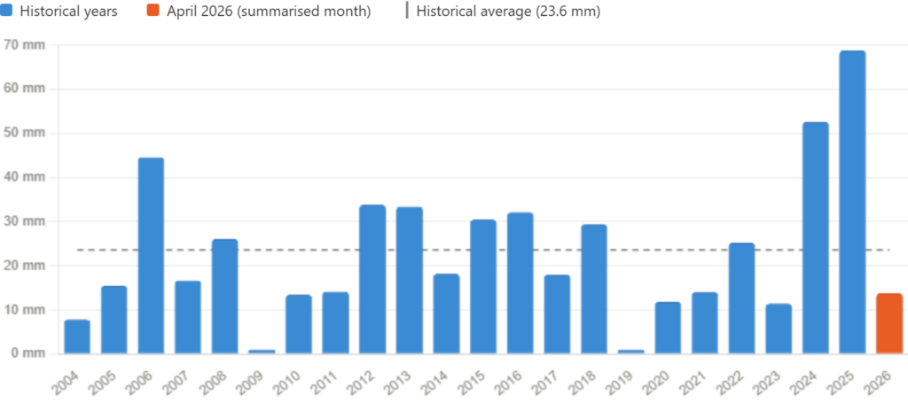
Total rainfall for April 2026 was 13.8 mm, making it a considerably drier-than-average month. All measurable precipitation fell within a narrow three-day window at the start of the month: 4.2 mm on the 4th, 5.8 mm on the 5th, and 3.2 mm on the 6th, likely attributable to a frontal system moving through the area. From the 7th onwards, the month was essentially dry, with only negligible amounts (0.4 mm and 0.2 mm) recorded on the 16th and 17th respectively, and no rain at all during the final ten days.
Against a historical mean of 23.6 mm for April (based on station records from 2004 to 2025), the month’s total represents roughly 58 % of the average — a deficit of approximately 9.8 mm. Measured against the historical median of 18.1 mm, which is a more robust central measure given the notable variability in the dataset, April 2026 still falls short by around 4 mm. As shown in the chart above, precipitation in April has ranged from as little as 1.0 mm (2009 and 2019) to as much as 68.8 mm (2025), highlighting the considerable year-to-year variability typical of spring in this region. The two preceding years were both well above average — 52.6 mm in 2024 and an exceptional 68.8 mm in 2025 — making 2026’s total particularly striking by contrast, though it is by no means the driest April on record.
Overall Assessment
April 2026 was a cool, settled, and largely dry month. The defining characteristic was the dominance of northerly and north-westerly airflow throughout most of the period, which suppressed temperatures, kept humidity at moderate levels, and ultimately blocked the development of any significant precipitation-bearing systems after the opening week. The brief warm spell centred on 15–17 April, when the only 16 °C+ temperature of the month was recorded, provided a temporary but welcome break from the prevailing cold pattern.
From a hydrological perspective, the month’s rainfall total of 13.8 mm represents a clear shortfall relative to historical norms, coming in at under 60 % of the long-term April average. This follows two successive above-average Aprils and places 2026 in the drier third of the historical distribution, though it does not approach the exceptionally low totals of 2009 or 2019. Overall, April 2026 was an unremarkable transitional month — neither severely cold nor warm, neither notably wet nor a record drought — but distinctly on the cool and dry side of the seasonal average.