This analysis was produced with the help of artificial intelligence, based on the weather data provided by the user.
October 2026 was a remarkably mild autumn month. It was the second warmest October in the station’s 24-year record, it passed without a single frost, and it saw the second highest October air pressure ever measured here. Rainfall was close to normal, slightly below average, while humidity stayed high and the month was largely grey and damp. The observations below are drawn from continuous 30-minute measurements at the station, and the comparisons use the full October record from 2003 to 2025 — 23 previous Octobers.
Weather Analysis
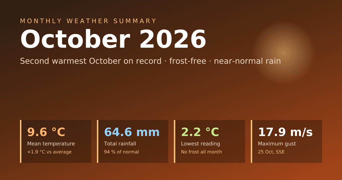
The mean temperature for October 2026 was 9.6 °C, which is 1.9 degrees above the long-term October average of 7.7 °C. That makes it the second warmest October in the record, surpassed only by the exceptional October 2020 (11.4 °C) and just ahead of 2022 (9.5 °C) and 2024 (9.4 °C). Three of the four warmest Octobers on record now fall within the last five years. Averaged over the month, daytime highs reached 11.5 °C and nights fell to 7.5 °C. The narrow daily range of about four degrees reflects persistent cloud and moist southerly air.
The maximum temperature was 16.2 °C, measured on 3 October at 16:30. That is above the long-term average October peak of 14.9 °C and ranks sixth in the record, though some way short of the warmest October reading of 17.9 °C from 2020. Only two days reached 15 °C, the 3rd and the 6th, so the month’s warmth came less from warm afternoons than from the consistent lack of cold weather.
The minimum temperature was 2.2 °C, recorded on 18 October at 08:30 and matched again the following morning. The long-term average October minimum is −0.9 °C, and in the coldest years the station has fallen to −4.8 °C (2003) and −4.7 °C (2012). October 2026’s minimum is the fifth mildest in the record, and the month was entirely frost-free — only the ninth October out of 24 to stay above zero. Only three nights dropped below 3 °C, all during the calm high-pressure spell of 18–20 October.
Within the month, the temperature curve had three distinct phases. The first ten days were the warmest, averaging 11.4 °C, with 6 October the warmest day at a daily mean of 13.9 °C. A sharp change came on 10 October, when colder air followed a deep low and the daily mean fell to 5.2 °C. The middle period from 11 to 20 October averaged 7.7 °C and included the coldest day of the month, 19 October (5.1 °C). The final third recovered to 9.6 °C as southerly winds returned, before the month closed on a cooler note at 7.2 °C on 31 October.
Humidity averaged 90.5 %, above the long-term October mean of 88.3 % and the eighth most humid October on record. Individual readings ranged from 50.6 % on 6 October, when a dry, gusty southwesterly flow briefly cleared the air, to 98.1 % on 17 October. On four days the daily average reached 95 % or more — 1, 2, 16 and 24 October — when fog, drizzle or low cloud kept the air close to saturation around the clock.
Mean air pressure was 1016.5 hPa, 4.9 hPa above the long-term October average of 1011.5 hPa and the fifth highest October mean on record. Behind that average lay an unusually wide range. The month opened under a strong high (1036.8 hPa on 1 October), but pressure then fell steeply and reached a low of 985.4 hPa on 9 October at 09:00 as a deep low passed, bringing the month’s heaviest rain. A powerful anticyclone then built in, and on 19 October at 13:30 pressure peaked at 1039.7 hPa — the second highest October reading in the record, exceeded only by 1040.9 hPa in 2016. Another low-pressure episode followed on 25–26 October, before pressure rose again to close the month near 1030 hPa. The 54.3 hPa spread between the extremes reflects a month that swung repeatedly between deep lows and strong highs.
Wind averaged 3.1 m/s, close to the long-term October average of 3.0 m/s (2.8 m/s if the unusually high 2020 value is excluded). The maximum gust was 17.9 m/s, from the south-southeast on 25 October at 19:30. That is somewhat below the long-term average October peak gust of 19.4 m/s and sits mid-table in the record, well short of the stormiest Octobers, 2019 (25.7 m/s) and 2006 (25.5 m/s). The windiest stretch ran from 25 to 27 October, with daily mean wind speeds above 5 m/s on all three days. The prevailing directions were south-southwesterly, south-southeasterly and southeasterly — a mild airflow from the southern sector that explains much of the month’s warmth. Under the high in mid-month, winds fell almost calm, with daily means barely above 1 m/s on 18 and 19 October.
Rainfall Analysis
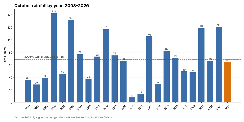
Total rainfall for October 2026 was 64.6 mm, against a long-term October average of 68.8 mm. The month therefore delivered 94 % of normal October rainfall, a small deficit of about 4 mm, and ranks fourteenth of the 24 Octobers in the record, almost exactly in the middle. The wettest Octobers remain 2006 (142.4 mm) and 2008 (132.0 mm), followed by the two most recent years before this one, 2025 (120.8 mm) and 2023 (118.6 mm). At the other end, October 2015 produced only 7.8 mm and 2016 just 12.8 mm. The average of the last ten Octobers is 70.5 mm, so this year was slightly below the recent norm as well.
Rain fell on 16 days at 0.2 mm or more, and on 12 days at 1 mm or more. Six days produced at least 5 mm, but only one exceeded 10 mm: 9 October with 18.6 mm, the wettest day of the month. Unlike September, when a single cloudburst dominated the total, October’s rain fell mostly as steady frontal rain of moderate intensity. The heaviest half-hour amount was 3.4 mm, on the morning of 9 October, and the highest rain rate was a brief 45.4 mm/h shortly after midnight on 26 October.
The wettest spell of the month came between 9 and 12 October, which together produced 34.2 mm — more than half of the month’s total — as the deep low of 9 October was followed by several days of showery weather. The longest dry spell was five days, from 18 to 22 October, under the strong high-pressure system. The final week brought a further 18.8 mm, mostly on 23 October (5.6 mm) and 26 October (9.6 mm), before the last two days turned dry. Split into thirds, the month’s rain fell as 25.8 mm, 20.0 mm and 18.8 mm, a fairly even distribution.
Seen in the context of the season, October continues the run of moderate, near-normal autumn rainfall after a wet early summer. June 2026 had 92.6 mm (average 37.6 mm), July 77.6 mm (average 52.7 mm), August only 34.2 mm (average 74.1 mm), September 66.0 mm (average 53.3 mm) and now October 64.6 mm. The five months from June to October together produced 335.0 mm, against a long-term average of 286.5 mm — about 117 % of normal.
Rainfall Comparison Chart
The chart below shows total October rainfall for every year from 2003 to 2026, with October 2026 highlighted. The dashed line marks the 2003–2025 average of 68.8 mm. This year’s total sits just below the line, in the middle of a very wide range that extends from 8 mm in 2015 to 142 mm in 2006. October is one of the most variable months at the station: totals above 100 mm have occurred in six different years, while four Octobers have produced less than 30 mm. Against that background, 2026 was an unremarkable, near-normal year.
Overall Assessment
October 2026 was a mild, humid and frost-free month with near-normal rainfall. Its mean temperature of 9.6 °C was 1.9 degrees above average and the second highest in the record, exceeded only by 2020. As in September, the warmth came from the absence of cold weather rather than from warm days: the maximum of 16.2 °C was only moderately above the normal October peak, while the minimum of 2.2 °C was among the mildest recorded here, and the month never saw a frost.
The month’s most striking feature was its air pressure. A mean of 1016.5 hPa was well above normal, and the strong anticyclone of 18–20 October produced the second highest October reading on record (1039.7 hPa), only ten days after a deep low had pushed the barometer down to 985.4 hPa. These swings shaped the weather: the deep low of 9 October brought the wettest day and a sharp cool-down, while the high brought the month’s only dry, calm and chilly spell.
Rainfall of 64.6 mm, or 94 % of normal, placed the month squarely in the middle of the record. The rain came mostly as moderate frontal rain spread across 16 days, with the 9–12 October period accounting for more than half the total. Winds were close to average, and the strongest gust of 17.9 m/s on 25 October was below the typical October peak.
Taken together, October 2026 was a gentle and unusually mild autumn month: grey and damp at times, but without frost, storms or heavy downpours. It will be remembered mainly for its warmth — continuing a clear recent trend of mild Octobers — and for the powerful high-pressure system that briefly took the barometer close to its October record.
Key figures at a glance
| Measure | October 2026 | 2003–2025 average |
|---|---|---|
| Mean temperature | 9.6 °C | 7.7 °C |
| Maximum temperature | 16.2 °C (3 Oct) | 14.9 °C |
| Minimum temperature | 2.2 °C (18 Oct) | −0.9 °C |
| Mean humidity | 90.5 % | 88.3 % |
| Mean air pressure | 1016.5 hPa | 1011.5 hPa |
| Pressure range | 985.4 – 1039.7 hPa | — |
| Mean wind speed | 3.1 m/s | 3.0 m/s |
| Maximum gust | 17.9 m/s (25 Oct, SSE) | 19.4 m/s |
| Total rainfall | 64.6 mm | 68.8 mm |
| Rain days (≥ 0.2 mm) | 16 | — |
| Wettest day | 18.6 mm (9 Oct) | — |